


In the late 16th century, cartography became a useful tool for legal purposes. It is thought that the Elizabethan map of Blakeney Haven was commissioned to provide visual evidence for a Court case to decide who had the ‘right of wreck’ on Stiffkey sands. One of the wrecks in question has been identified as ‘Thomas’, a Scottish ship which came to grief in February 1586. The argument was between the Manor of Wighton, then part of the Duchy of Lancaster, versus Cley Manor which was in the ownership of Sir William Heydon. The coats of arms featured on the map imply that it was Heydon who commissioned it.
The drinking peasant, in the style of Bruegel, was the trigger for establishing that the map was almost certainly the product of John Darby. Only a few of Darby’s maps survive but they each demonstrate his cartographic and artistic skills, alongside touches of mischievous humour.
Unfortunately, the original map has long since disappeared. In 1846 it was in the possession of the representatives of the late John Winn Thomlinson Esq of Cley Hall. Mr Thomlinson died in 1835; he was survived by his wife but they had no children. The estate was sold to William Hardy in 1839 and subsequently bequeathed to William Cozens-Hardy in 1842. Mrs Thomlinson died in 1849.
Between 1835 and approximately 1849, three different copies of the map were made. These were followed by several more in the 20th century, culminating in a composite version in 1992. An updated list of the different versions is shown below.
Over the past 25 years, a greater understanding of the map has evolved. In large part this is thanks to the Blakeney Area Historical Society, its lectures and its journal – not forgetting its forerunner, the Blakeney History Group, which published The Glaven Ports by Jonathan Hooton in 1996.
The following list provides links to relevant articles in the BAHS journals. More may well follow! BAHS members may access them all, once they have logged into the membership area by clicking here. Once logged in return to this page and click on the relevant links below. If you wish to join the BAHS, please click here.
Articles relevant to the 1586 Map in Glaven Historian Journals


Clicking on the links below they will open in a separate tab or window.
GH1 – Hooton, J. (1998).
1586 Map of Blakeney Haven and Port of Cley: Part I, pp 3-7.
GH2 – Wright, J (1999).
1586 Map of Blakeney Haven and Port of Cley: Part II, pp3-8
GH9 – Frostick, R (2006).
The Map of Blakeney Haven and Port of Cley – 1586: pp29-30.
GH9 – Wright, J (2006)
Blakeney’s ‘Map of the World’ in 1368: p49-55
GH10 – Hawes, F (2007)
Maps: pp71-72
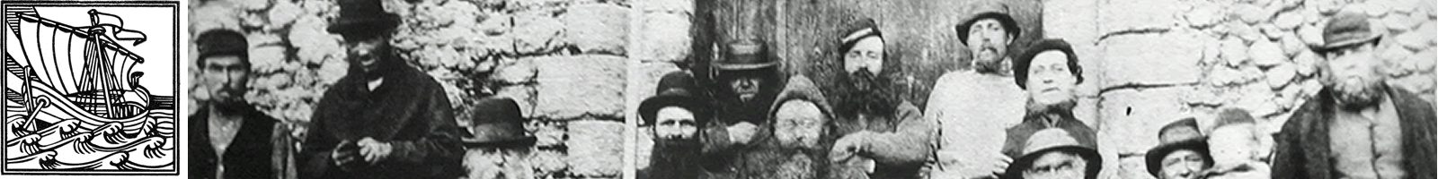
(nb: Mrs Cooke took the displayed photo; the name of the half hidden person is not known)
GH12 – Ebdon, J (2010)
History of the Cley Hall Estate: p85-86
GH15 – Cooke, D (2017)
Sir William Heydon and his heraldic heiresses: pp40-47
GH16 – Cooke, D; Hooton, J; Harrison, N (2018)
John Darby: Land Surveyor in East Anglia in the late Sixteenth Century:pp3-10
GH16 – Wright, J (2018)
North Norfolk from the Sea – Marine Charts before 1700: pp23-43
GH17 – Hawes, F (2020)
Some issues concerning the 1586 map of Blakeney Harbour: pp 37-38
Other Publications
Hooton, J. (1996). The Glaven Ports. Publ: Blakeney History Group
-Map of Blakeney Haven & Port of Cley Executed in the year 1586: pp 106-109.
-The Tidal Harbours Commission: pp235-240
Updated List of different versions of the 1586 Map
19th Century


The 1830s – Norwich Castle Museum
Print of Blakeney Haven and surrounding area. Hand coloured lithograph, about 1830s. Printed by the Government Printers, Standidge & Co, London
1835 – Palmer
Henry Robinson Palmer (1795-1844) was an eminent civil engineer and a colleague of Thomas Telford. He sketched an original copy of Blakeney Haven (it is presumed with up-to-date surveying techniques) in 1835. It is not known why he made the map but is likely to have been on behalf of Ordnance Survey; they were revising the one inch maps of North Norfolk during 1836-37, to be printed in 1838. Copies of this map were also printed by Standidge & Co.
1846 – Tidal Harbours Commission
The Palmer map was attached as an Appendix to the 2nd Report of the THC, along with a simplified version of the 1586 map ‘procured from the late lord of the Manor’ (John Tomlinson who died on Boxing Day in 1835).
1846 – Cooke-A (36”w x 29”h)
‘ J.G. 1846’ is written in tiny black ink at the bottom left of the map. The cartouche spells Thomlinson without an ‘h’. Privately owned.
Late 1840s – Long (33”w x 26”h) The approximate date of this version was identified because ‘the writing was done by a metal pen nib, which was only in use from the middle of the 1840s, not by a quill pen’. The green background on the Oulton coat of arms is correct. It is possible that WJJ Bolding painted this map; he was known for his photography but was also an artist. It was inherited by his great niece and later donated to the Norfolk Records Office.
20th Century


1906 – Norfolk & Norwich Naturalists Society:
The President’s Address, given by Charles A Hamond, is about his collection of maps; it is published in Transactions Vol VIII part III, with a block copy of the Long map on p336.
1926/27 – Basil Cozens-Hardy:
Cozens-Hardy uses the NNNS block in an article for the Norwich Union. The following year, he writes about “Cley-next-the-Sea and its Marshes” for the N&N Naturalists Society, Transactions Vol XII part III. A copy of the Long map is reproduced between pages 358 & 359.
In 1936, he produced an article for the Norfolk Record Society on The Maritime Trade of the Port of Blakeney, Norfolk, 1587-1590; it includes a reproduction (of the NNNS copy) in the NRS Journal, Vol VIII p16.
1929 – Cooke-B:
It is possible that Dr Arthur Cooke acquired the 1846 map (at the same time as a plot of land) in the 1929 sale of Blakeney Manor Farm. This might account for the reason he commissioned a dyeline copy to be made in 1929. It is signed F.E.W. but the initials have never been identified.
In 1930, Dr Cooke arranged for a photo-static reproduction of the 1929 version (made by Ordnance Survey) and donated it to the British Library.
1930 – Burrows:
This is a much less accurate copy with colourful additions and has the following text ‘Copied and painted by Francis Seacombe Burrows from an antique map. The property of F. Monement Esq of Cley. August 1930’. Burrows’ parents lived in Blakeney. It was donated to the Norfolk & Norwich Archaeological Society but its present whereabouts is not known.
The 1950s – Catling:
Peter Catling traced the Cooke-B map and made at least six dyeline copies.
1992 – Sayers:
Godfrey Sayers, a local artist, used the Cooke and Long 19thC maps to produce a composite version. It took over 600 hours to complete. A run of 250 copies were printed and the map has featured in several books and on book covers. After it was finished, a celebratory photo was taken, in the Cooke’s old garden, with five versions of the 1586 map.
Other Maps which show the evolving shape of Blakeney Haven
1681-1693 – Captain Greenville (or Greenvill) Collins, RN
Collins, a hydrographer, was commissioned by Samuel Pepys to survey the country’s coastline, in 1681. The project took seven years to complete and resulted in Great Britain’s Coasting Pilot being published in two volumes in 1693. The Blakeney & Cley chart was dedicated to Admiral Sir Cloudesley Shovell.
1797 – Faden’s Map of Norfolk
A digital version was redrawn in 2005 by Andrew Macnair. Both versions are accessible on http://fadensmapofnorfolk.co.uk
DC/Summer 2020
Except for the 1929 map, the images are all taken from Godfrey Sayers’ map, with his permission. Copies of his map (1992) are still available. Contact the BAHS Secretary for further details.